
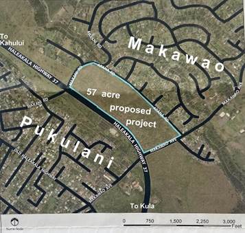
The Makawao, Pukalani and Kula communities should strongly opposes the proposed project because: a) the State Land Use Commission’s “Land Use” designation, b) the current Maui Island Plan, c) the current Upcountry Community Plan for Makawao, Pukalani and Kula, and d) zoning ALL have this 57.616 acre site clearly designated for agricultural use. The various plans all express the community’s desire to keep this parcel in agricultural use and to provide a visual break between Makawao and Pukalani’s residential/commercial areas.
Reference: Makawao, Pukalani and Kula (Upcountry) Community Plan Page 22
https://www.mauicounty.gov/DocumentCenter/View/1714/Makawao-Pukalani-Kula-Community-Plan?bidId=
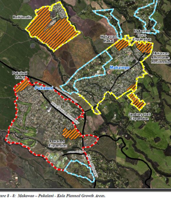
Maintain the open space areas along the Makawao-side of Haleakala Highway Bypass to allow a distinct separation between Pukalani and Makawao.
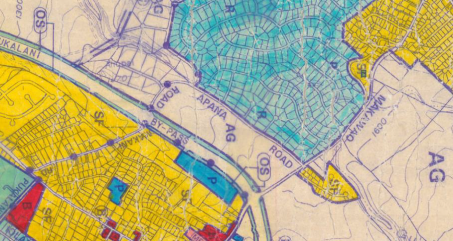
Also, see the land designation on the Upcountry Community Plan MAP:
https://www.mauicounty.gov/DocumentCenter/View/10787/CP-MakaPukaKulaCP?bidId=
Maui Island Plan, https://www.mauicounty.gov/DocumentCenter/View/84683/Chapter-8?bidId=
Page 8-37 Protecting Agricultural Lands Preserving rural character, protecting prime and productive agricultural lands, and maintaining a separation between communities are significant challenges.
Pages 8-37 and 8-38 Maintaining a Separation between Communities
If the region continues to grow as it has in the last two decades, separation between communities will become blurred and each community will lose its unique identity. Future development must be focused within existing communities or be adjunct to existing urban areas, and provide, as much as possible, that large areas of open space are maintained between communities.
Also, see the Directed Growth Boundary designation on the Maui Island Plan MAP:
Maui Island Plan PDF Page 79 Growth Boundary Map

Page 8-39 https://www.mauicounty.gov/DocumentCenter/View/84683/Chapter-8?bidId=
Maui Island Plan Map Bool Map M-11
https://www.mauicounty.gov/DocumentCenter/View/84607/M-11
Summary: As can clearly be seen, ALL the maps provide clear intention in the form of Maui County’s ordinances (Maui County Code) to keep this 57.616-acre area in agricultural use with NO urbanized development.
General Discussion Around 1988-1989 landowner Maui Land and Pineapple Company requested to leave this area zoned for agriculture and the 57 acre site not be used for a proposed high school (King Kekaulike).
Subsequently, the Upcountry Community Plan was written in 1994, and was adopted into law by the Maui County Council in 1996. Both the Upcountry Community Plan and the Maui Island Plan speak against using this site for the proposed project’s housing proposal since the Upcountry Community Plan wants a distinct separation between Pukalani and Makawao. This intervening area should be left as an open space agricultural area. The Plans strongly recommend that the project area parcel be left open and remain for agricultural use, not housing. Furthermore, referring to the parcel, as being a part of Makawao or a part of Pukalani, is fallacious; the parcel is to be an open space area located between the towns of Makawao and Pukalani.
With regard to the description of the proposed project:
“. . . With the primary exception of Haleakalā Highway (Highway 37) to the Southwest, the land is primarily surrounded by single family residences with Haleakalā Highway to the Southwest, Makawao Avenue to the Southeast, Apana Road along the Northeast boundary, and Makani Road along the Northwest border.”
Actually, it is not surrounded by single-family residences; the description is totally incorrect. The area has homes along only one boundary (Apana Road).
The land has been agriculturally productive and for decades has been used for pineapple farming.
Both the Upcountry Makawao-Pukalani-Kula Community Plan and the Maui Island Plan clearly designate the land parcel being proposed for use by the Boschetti-Makawao development project as agricultural land. The Upcountry community should strongly feel that this parcel should be left open and undeveloped in order to separate the different communities (Makawao and Pukalani). Pukalani and Makawao wish to maintain their own identities rather than becoming one large sprawling, undefined urbanized area. The proposed project would dramatically change the current Upcountry landscape and would have a huge impact since it goes against and ignores what their community and island plans clearly state.
Upcountry Makawao-Pukalani-Kula Community Plan Page 20 https://www.mauicounty.gov/DocumentCenter/View/1714/Makawao-Pukalani-Kula-Community- Plan?bidId=
Preserve and enhance the “country” atmosphere in all communities by maintaining the small-scale, unique and independent character of each of the three sub-regions. “Country” atmosphere is defined by building style, a low-density mix of residences, ranches, open spaces, greenways, plantings and cultivated lands.