
What do you want for West Maui?
The Honoapi‘ilani Highway Improvements project (a collaboration between the Federal Highway Administration and the Hawai‘i Department of Transportation) is requesting public comment about the “Purpose and Need” section of the Federal Environmental Impact Statement required before the project can move forward to the next planning phase. With your input, you can help the planners identify the key issues that this project should address.
The current Purpose and Need listed in the draft (per a recent meeting) include:
-
Improve roadway reliability
-
Address existing and future vulnerability to ocean hazards
-
Provide consistent roadway system connections
-
Improve public safety
What other needs can you think of?
Public comment is open until March 25, 2022. You may submit public comment using the form at this link.
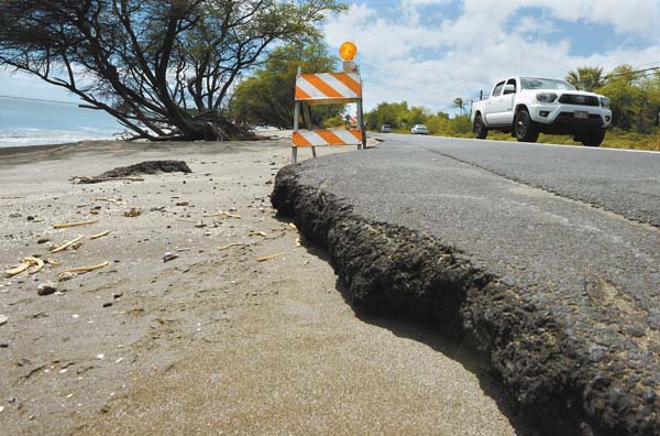
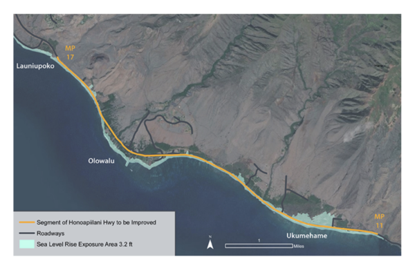
This project’s limits extend approximately 6 miles from the sandy beach strands of Papalua Beach Park near Manawaipueo Gulch, continues through Ukumehame and Olowalu to the easternmost point of Lahaina Bypass Road in Launiupoko (see map below). As we’ve witnessed in many areas but especially in this part of the highway, Maui’s coastal belt roads are extremely vulnerable to seasonal ocean swells along with storm surges that cause shoreline erosion and damage.
For additional references and to deepen your research about these impacts, you may refer to the following reports:
- Hawaii Highways Climate Adaptation Action Plan (2021),
- Statewide Coastal Highway Program Report (2019), and
- Hawaii Statewide Transportation Asset Management Plan (2019).
Additional project background from the Honoapi‘ilani Highway Improvements website:
The scenic coastal Honoapi‘ilani Highway (State Route No. 30) is a single two-lane highway that currently serves as the primary access route to and from West Maui. It is part of the island’s belt road system which operates as a two-lane principal arterial on the National Highway System (NHS) and Freight Network System (FNS). The undivided highway provides two 12-foot travel lanes with 4-foot to 8-foot shoulders. Most of the highway terrain is relatively flat, lying close to mean sea level.
The project limits extend approximately 6 miles from the sandy beach strands of Papalua Beach Park near Manawaipueo Gulch, continues through Ukumehame and Olowalu to the easternmost point of Lahaina Bypass Road in Launiupoko.
Project goals:
- Improve our traffic
- Improve the reliability of access to and from West Maui
- Provide consistent roadway system linkages
- Improve public safety for emergencies
- Support alternative transportation modes
- Protect our resources
- Complement land use and preservation plans
- Protect natural resources
- Minimize environmental impacts
- Consider impacts on groundwater resources
- Protect and minimize impacts on archaeological resources


